What Is The Purpose Of A Water Conservancy Dam?
A dam is a structure that is built to stop the flow of water. This provides water to be used in irrigation, human consumption, industrial use, and aquaculture and it also prevents floods.
Brief History
The Dutch colonizers began settling along the coastlands of Guyana. They noticed that there would be periods of heavy rainfall which would cause flooding. The water which would accumulate would be very difficult to remove. The Dutch started to implement drainage and irrigation systems in the 1600s by having paid slaves and indentured East Indians digging waterways using shovels. Advancements in these systems were established in 1838 when canals and kokers (sluices) were built. One of the major innovations of the time was the building of water conservancies to retain fresh water from upland streams during the dry seasons and release it via irrigation canals and head regulators.
The East Demerara Water Conservancy was designed by the Scottish architect William Russell and was constructed around 1880 from several existing drainage systems to form a more efficient water storage and distribution system and to act as a flood control reservoir.
Over 500,000 residents inhabit the basin that lies below and between the sea-wall and the EDWC Dam in a 48 km band from Georgetown to Mahaica. The EDWC serves to irrigate thousands of hectares of rice and other crops within this area by storing rain water for dry periods and it also provides one of the primary source (about 60%) of drinking water for the capital city of Georgetown.
Location
The EDWC is located 15 miles south of the most densely populated section of the Guyana Coast. It is bounded to the North by a man-made 45-mile earthen dam and to the deep south by a natural topographic rise composed largely of ancient coastal dune formation over geological time. The EDWC Dam is constructed of clay and pagasse.
Physical Features Of EDWC
- Surface Area – 130 Sq. miles
- Catchment Area – 200 Sq. miles
- Length of Conservancy Dam – 45 miles
- Full Storage Level – 57.5 ft GD
- Dead Storage Level – 53.5 ft GD
Two Major Projects Done On EDWC:
Climate Change Development
The Japan International Cooperation Agency (JICA) assisted many countries that were vulnerable to climate change by providing monetary aid to improve the drainage and irrigation systems.
Northern Relief Channel
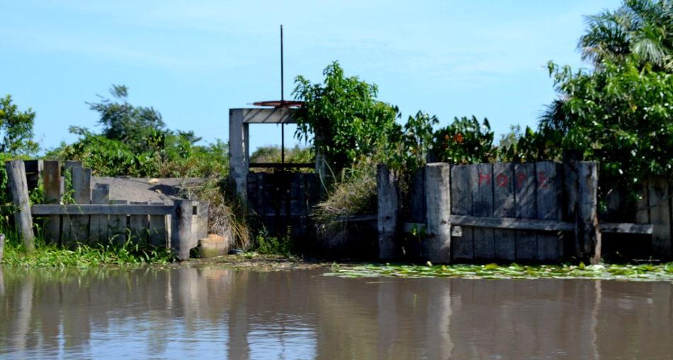
In 2005 Guyana experienced major flooding throughout the entire country. East Coast Demerara was affected the most by this since there was an overtopping of the already deteriorating conservancy dam. The flood shone a light on how susceptible the EDWC is to the changing weather conditions. The Hope Canal seeks to provide the release of excess water in the East Demerara Water Conservancy when it is at risk of once again, over-tapping. The Conservancy Adaptation Project (CAP) was established in 2005 in order to assist the government in adapting to changes caused by climate change. The goal was to lessen the possibility of catastrophic flooding along Guyana’s low-lying coastal regions, which are also at risk from sea level rise.
Improvements Made Possible By The Conservancy Adaptation Project (CAP)
- The CAP modeling studies have identified important key regions where interventions would result in the greatest enhancements to the east coast drainage systems and EDWC discharge capacity, both of which are essential for flood zone management. For a set of prioritized expenditures intended to dramatically lessen the system’s susceptibility to sea level rise and high rainfall, pre-engineering designs have been developed.
- In order to help the government control water levels in the EDWC and boost drainage capacity, the CAP has sponsored particular infrastructure investments. In particular, the two sluices / kokers at Lama, on the conservancy’s eastern side, were repaired to help lower water levels when necessary. Additionally, a pontoon and hydraulic excavator were purchased as part of the project to make it simpler and quicker to access the dam’s need-repair sections.
- The identification of several short- to medium-term strategic investments totaling more than US$123 million made possible by the CAP includes the rehabilitation of important drainage relief channels, improved EDWC transportation, a strengthened EDWC dam, and various east coast drainage systems investments.
The Man Behind The Design: William Russell (1827-1888)
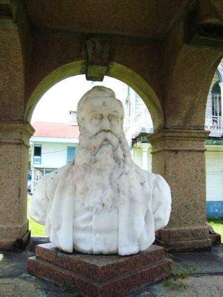
Image of the William Russel Monument. Photo Credits: Amanda Richards (https://www.flickr.com/photos/arichards-gallery/3529957454)
The Hon. William Russell was born at Myreside, Elgin, on 13th March 1827, and died in Georgetown, Demerara, on 28th March 1888, at the age of sixty-one.
A well-known planter, Russell is remembered for his work in the nineteenth century solving the problem of how to bring water into Georgetown. There had been failed efforts before his, one of which saw the water in a canal designed to flow into the city, flow in the opposite direction because of the gradient of the land. Russell went out into the bush to study the water levels and eventually came up with a viable solution. Perhaps however his chief claim to the gratitude of his fellow colonists was the elaboration of a system of water supply for the principal districts under cultivation, including also the city of Georgetown and the populous villages of the East Coast Demerara.
The William Russell Memorial is located in the compound of Georgetown’s City Hall, on Avenue of the Republic, Lacytown, Georgetown. This commemorative monument was initially unveiled on November 29, 1892, in a small garden in Stabroek Market Square which was renamed William Russell Square.
References:
- https://openknowledge.worldbank.org/handle/10986/17843
- https://en.m.wikipedia.org/wiki/East_Demerara_Water_Conservancy
- https://nenp.facebook.com/243603706068114/photos/a.427154304379719/6099189
- https://www.southamericanpostcard.com/cgi-bin/photo.cgi?3guianas-AAAA9368
- https://documents1.worldbank.org/curated/en/544201468036366779/pdf/866350WP0
Discover more from Things Guyana
Subscribe to get the latest posts sent to your email.

